Natural Landscape
Iqaluit is located on the southeast part of Baffin Island, in the Everett Mountains. Baffin Island is the largest island in Canada, and the fifth largest in the world. The northern part of Baffin Island is mountainous with many fjords, while the southwestern part has plateaus and lowlands. There are also a few freshwater lakes and rivers.
Nunavut is Canada's largest and newest territory. It is 2 million square kilometers, which is one fifth of the county's landmass. There are many islands in Nunavut including: Baffin, Devon, Ellesmere and Victoria. Victoria Island is shared between Nunavut and the Northwest Territories. It is Canada's second largest island and the eighth largest in the world. The Queen Elizabeth Archipelago is a group of islands made up of frozen, snow covered rock.
The highest point in Nunavut is Barbeau Peak in Quttinirpaqq National Park which is 2616 meters high. It is part of a mountain range called the Innuitian Mountains. There are no trees because the climate is too cold. The landscape is comprised of rock, ice and glaciers. The part of Nunavut that is located below the Arctic Circle is part of the Canadian Shield.
To the north on Nunavut is the Arctic Ocean, to the east is Baffin Bay and to the south is Hudson Bay.
Some things about the landscape of Iqaluit that has helped it grow are: Iqaluit is located near water so it is more accessible than other cities in Nunavut. Also, it is located in the southern part of Nunavut, so the climate is not as harsh as the northern communities. There are also many challenges that the landscape presents. There are almost no roads, so if a person wants to get from one place to another, they have to travel by boat or small plane. Supplies have to be brought to Iqaluit by ships during the summer. Since it's so hard to obtain food, the prices of food are almost doubled.
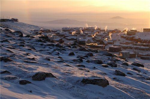
The snow covered hills around Iqaluit, Nunavut.
Iqaluit is located on the southern part of Nunavut, so it is easier to transport supplies there from other provinces. Since it is near water, ships can easily go to and from Iqaluit.
